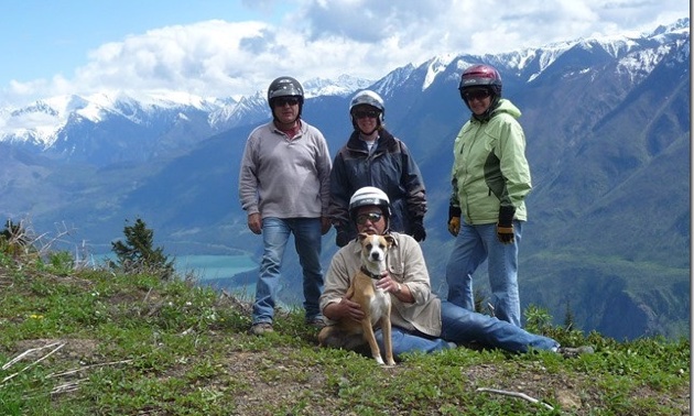
This adventure took us to a remote part of the province of British Columbia: south of the Chilcotin plateau into the man-made lakes north of Lillooet. Our riding partners on this trip were our friends Tom and Beryl Maxwell and my always faithful riding partner Cooper.
We fueled up in Lillooet on a beautiful sunny afternoon and headed up the Yalakom/Bridge River Valley Road to a left-hand turn-off towards Carpenter Lake. This is a paved road, with short patches of gravel where the pavement has broken up due to frost, and a few rock slides.
The earthen dam that holds back the water of Carpenter Lake comes into sight after a few miles. It has an overflow water spillway that goes into the edge of the mountain and forms the Bridge River. We stopped along the top of the dam and took a few pictures, then proceeded along the north side of Carpenter Lake. We could see across the lake the two concrete intakes where the water is diverted through the mountain to the hydro generators at Shalath in the next valley to the south, on Seton Lake.
About two-thirds of the way along the north side of the lake we came to the Gunn Creek campsite, a free BC Hydro camping area that is clean, well maintained, and hardly ever used. It is also along the edge of Carpenter Lake and near the old mining town of Minto City. This town was built for a gold mine in the area in the 1930s, but when the lake was built for power consumption the townsite was flooded.
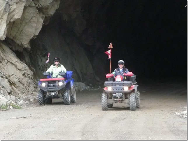
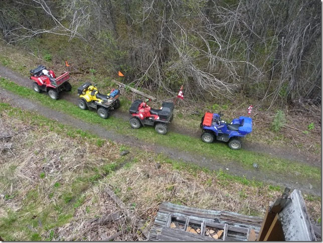
Delle Megyesi and Beryl Maxwell on their ATVs. — Phil Megyesi photo
When we were there the lake was at its low point and we were able to walk the old townsite. We saw stone walkways, old rusted farming equipment, rock building foundations and other remnants. The Minto hotel was moved just up the road a few miles to Gold Bridge when the lake level rose due to water backing up behind the dam, and stood there until a fire destroyed it.
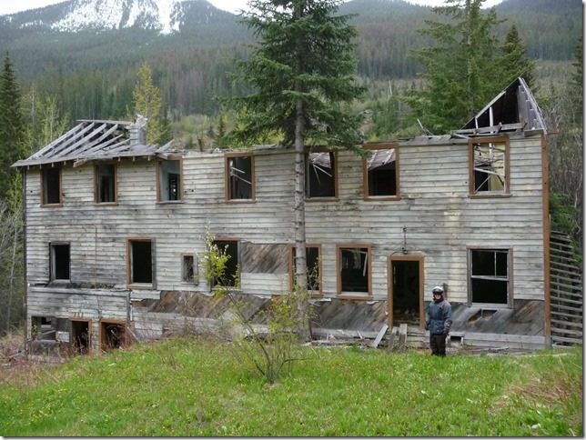
The remains of the Minto hotel. — Phil Megyesi photo
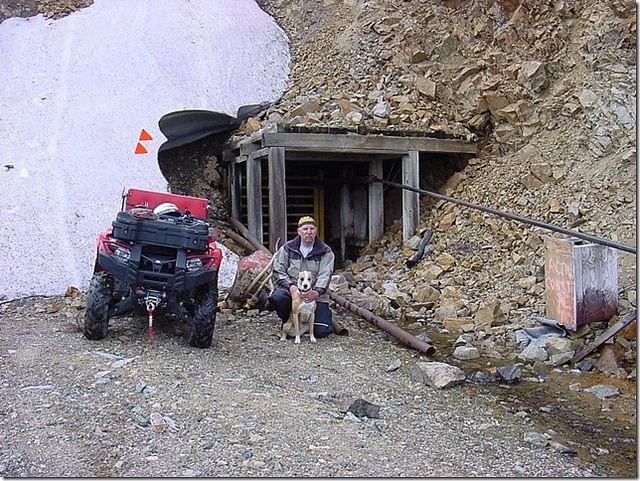
Exploring old mines near Minto City, an abandonded mining town. — Phil Megyesi photo
After a wonderful night listening to the rushing Gunn Creek right outside our motorhome, we packed a lunch, unloaded the four-wheelers and headed up the road to the Tyax Wilderness Resort and Spa, a few miles north of the Carpenter Lake.
Near the mines there are abandoned buildings and homes. — Phil Megyesi photo
This resort has been there for years. We visited it 20 years ago when our two daughters were barely teenagers. The huge log structure sits on the edge of Tyaughton Lake, surrounded by private cottages and hobby farms.
Further up the road we came to Tyaughton Creek, winding its way down to Carpenter Lake. We had lunch at the forestry campsite where Relay Creek joins Tyaughton Creek. The road does continue north from that point, but we had been there before, so we headed back to camp.
Several miners have been prospecting in this area, and remnants of their search for gold have been left behind, including old log cabins and caved-in mine shafts.
Next morning, we broke camp and moved back down the lake to a small campsite below the Carpenter Lake dam. We unloaded the quads and headed up the road on the south side of the lake and over the mountain to Shalath. This road is gravel and has many, many switchbacks as it proceeds up the mountain and down the other side. It's definitely not for those who don't enjoy steep terrain.
The view from the road at many points is tremendous. You can see up the entire length of Carpenter Lake on one side and all of Seton Lake and the town of Seton Portage on the other side.
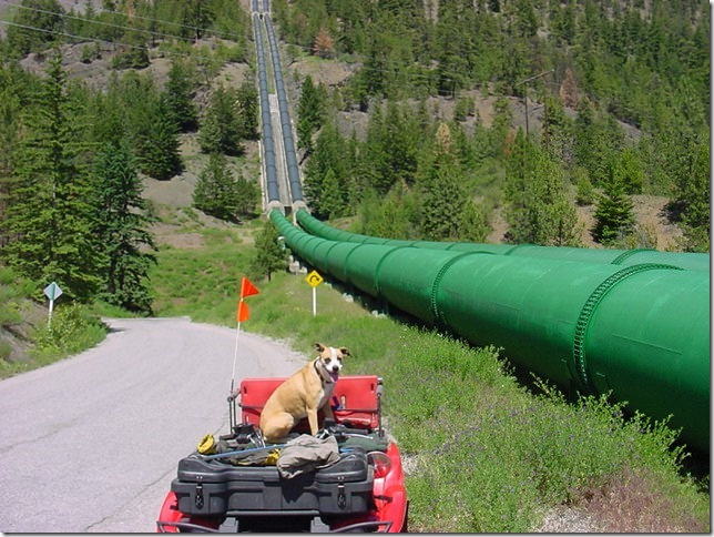
Four large pipes carry water that flows through the mountain from Carpenter Lake. — Phil Megyesi photo
Once we arrived at the bottom of the hill, we found paved roads once again and a hydro generating station that was producing power from the water that flowed through the mountain from Carpenter Lake in four large, 10-foot-round pipes. Contractors were in the process of painting these pipes a brilliant green, so they really stood out when you saw them coming down into the generating station. Further along the lake was another power-producing plant with more of these large-diameter pipes.
We found a small picnic site along the lake next to the railway line that passes through the town and had lunch.
While we were eating, the daily commuter shuttle that goes up and down the lake from Whistler to Lillooet passed by, with everyone on board waving, and the engine operator tooted a friendly hello. This service has been operating for years to move people in and out along the lake, as some have no means of getting supplies brought to where they live in remote areas.
After lunch we toured around the small town, seeing older cottage-style homes built years ago when the power station was being built. All the yards were filled with fruit trees and the smell of peaches, plums, pears, and apples hanging waiting to be picked. We spoke to some residents and they told us some of the history of the town and how a lot of Europeans had come to this part of British Columbia to find work many years ago, and had brought their families and fruit trees with them, and the trees are still producing to this day.
Of course with all the fruit comes bears, who love to eat these juicy morsels. Some of the residents have devised a system to warn of an intruding bear by means of ringing a large bell to chase them off. We didn't hear this while we were there, nor did we see any bears, but in this small community their system seems to work.
We toured around the lakeshore for a few more hours, passing through a couple of native reserves and small farms before we headed back up the hill. We found a small road that went along the mountaintop ridge under the powerline, and were able to get some fantastic pictures of the lakes far below us.
We had seen on this trip a great deal of history that had been built by those industrious men and women who had the forethought to take on the challenges of flowing water and to make it work to their advantage; to build the dams, tunnel through the mountains, and set up the generating stations that produce the power for those in other parts of the province who depend so much on it for their homes and businesses. The remote historical locations we visited and the breathtaking views from the mountaintops made this power trip worthwhile for all of us.


Comments