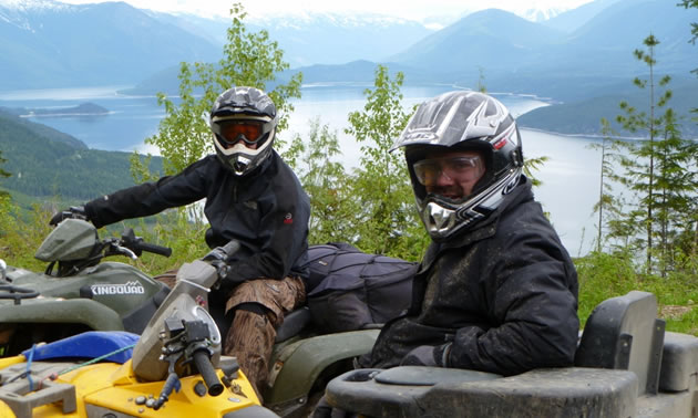
Tired of the women planning weekend shopping trips, book club nights and countless other “Girls Nights Out,” the boys finally had a revelation! Hey, why don’t we plan a trip that doesn’t involve more quality time with the wife and kids?
A couple of days later, “Boys Quadding Weekend” was the subject line of an email I received. I instantly responded, “I’m in!” Yes, it was time to dust off the ATV and go explore another piece of beautiful B.C.
After looking over our handy Backroad Mapbook, we decided the Arrow Lake Riding Area south of Revelstoke had everything we were looking for—recreation sites for our base camp; main haul logging roads to experience the thrill of high-speed riding; side roads and trails to add a bit more challenge; and amazing mountain and lake scenery.
Our trip was scheduled for late June 2012, and we had a good-sized crew coming. But, as usual, they started dropping like flies closer to the date. The excuses were rampant, especially given the very wet and cold weather we were experiencing. Nonetheless, a few of us still forged ahead—albeit we replaced the tents with an RV and added a few other luxuries to help endure the suspect weather.
Ready for an adventure
We left bright and early Friday morning, fully expecting to have to beat the weekend warrior crowd to find a nice campsite. Of course, we made a few pit stops and loaded up with food and drink before venturing south.
We got to the recreation site in the early afternoon and were shocked to see the place deserted. I guess the heavy rains over the last few days truly dampened other people’s camping spirits. We toured the recently revamped site, making a mental note to come back in the heat of the summer. The site was amazing, easily one of the top sites I have had the luxury of visiting over the years.
We set up camp in a nicely protected area away from the lake wind—thankful to the previous campers who left a nice load of wood. Of course, all did not go smooth. One of the quads wouldn’t start. A bit of cursing and a lot of monkeying around and we finally figured out that his battery was dead. So much for an evening ride—for him!
As can be expected, we had a late night so we weren’t too keen to get going first thing in the morning. This allowed our buddy enough time to go back to town for a new battery. In the meantime, we got all of the tools, extra gas and the much-needed Backroad GPS maps rigged up.
Trail blazing
Using the GPS maps as a guide, we were able to piece together a great ride up and over the ridge to the next valley. The amazing view of Upper Arrow Lake was quickly replaced by dramatic mountain peaks looming in the background. We burned up new and old roads trying to piece together a course that would lead up to Pingston Lake—if the snow would allow it.
Eventually, we got onto a road system that would allow us to shortcut over to the Pingston Valley—at least according to the maps. After a bit of careful navigation, we finally found the linking road. Unfortunately, it was covered in alder. Obviously, this road had not been used for years as the alder was well established with some as thick as an Olympic cyclist’s leg!
Since the road was only a few hundred metres in length, we decided to forge ahead anyway. The machines once again amazed us as they had no trouble cutting through the overgrown track. We were almost through when the next obstacle unveiled itself.
What appeared to be a small pool of water was anything but. The water ended being shockingly deep. The boys couldn’t believe it when the water engulfed my machine and came up and over my seat. Luckily, we all made it through.
However, the alder-covered road seemed to go on forever. I pulled out the GPS, only to discover we had, in fact, made it to the other road we were looking for. It was as overgrown as the last! No turning back now, so we continued ahead. There was only one bridge crossing left before we would hit the main road leading up to Pingston.
Unfortunately, we soon found out why the roads were so overgrown. This bridge, once a significant structure, had collapsed and now rested imposingly in the rushing water. Given the steep canyon and the volume of water, winching around the gap was not an option. Looks like we do have to turn around after all!
Surprisingly, we had no issues working back through the alder or swimming through the pool again. All was fine, until we got back to the original road. This is where the snow that we had no problem riding over on the way down posed an impenetrable barrier. Ha! Armed with shovels and winches, we broke through. But after all of this trail breaking, the day was getting long so we headed back to camp to share the stories of the day.
Worth every minute of it
On Day 2, we decided to try another ride to the alpine. This time, the destination was Paint Lake. Once again we used our Backroad GPS maps as our bible and were able to piece together another amazing ride.
We eventually got onto the road leading to the trailhead. Once again, the road was starting to show its age as alder crept onto it. This made for some fun riding, which soon turned into some even better riding.
Given the runoff from all of the snow, the water was now rushing down the trail. Once again the ATVs proved their worth as we ran over washout after washout with the added challenge of jumping around alder trees. We were almost at the top when the snow once again became too deep to bother to break through. We returned to camp content with one of the best rides ever.
Despite not getting to the ultimate destination on either ride, we all had grins from ear to ear. The Boys Quadding Weekend provided more than one good story and showed that with the right tools and a good map there is nowhere an ATV can’t go!
Russell Mussio is the co-owner of Backroad Mapbooks.


Comments